 |
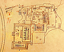
Detail of East Group of 1968 INAH map.
Jan. 2002 |
|
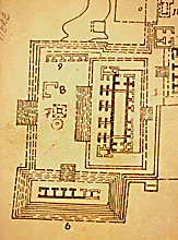 |
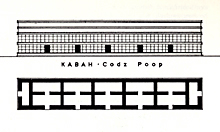
Detail of map at left; showing Codz Poop structure with 5 front doorways, leading to, in pairs, 5 front rooms and 5 back rooms.
Jan. 2002 |
|
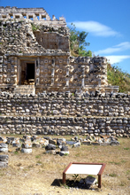 |
Official INAH sign in front
of right end of main facade.
Jan. 2001 |
|
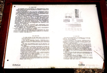 |
Official INAH sign seen in photo
above-right.
Jan. 2001 |
|
 |
Detail of INAH sign in photo at left;
description in English.
Jan. 2001 |
|
 |
Detail of INAH sign in photo at far-left,
with various diagrams (this photo splattered with rainwater and distorted
at top).
Jan. 2001 |
|
 |
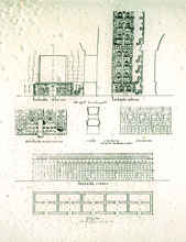
1975. "Kabah . Codz Poop" (elevation and plan).
Scanned from George F. Andrews, Maya Cities, Placemaking and Urbanization, 1975, p 45. Reproduced with permission of the University of Oklahoma Press. |
|
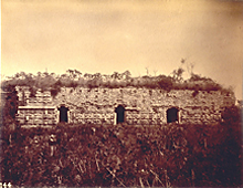 |
1888-1891. Front facade; showing the 3 surviving central doorways
of the original 5. The end rooms and doorways, here out
of photo at far-left and far-right, had fallen. One section,
here visible at far-left, retained well preserved medial molding and
masks covering both upper and lower tiers, crucial evidence
for rest of facade.
1888-1891 photograph by Henry N. Sweet as a member of the Thompson/Peabody expedition; scanned from 35mm slide of original photograph at Dumbarton Oaks. Reproduced Courtesy of the Peabody Museum of Archaeology and Ethnology, Harvard University. |
|
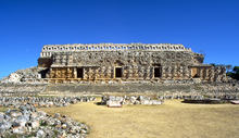 |
2003. Front (west) facade, partly
consolidated and restored 1951; showing surviving masks, some replaced; the door and lower wall at far-right were reconstructed.
Jan. 2003 (24mm lens) |
|
 |
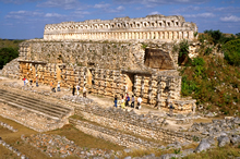
No other known Puuc building
originally had continuous masks covering both upper and lower
facade levels. The only surviving section with both upper and lower facade masks can be seen in this photo and in 1899-1891 photo above-center.
Nov. 1999 |
|
 |
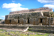
Showing collapsed right end; the door and lower facade at right completely restored; grand
staircase and 2 level terrace completely restored 1953.
Nov. 1999 |
|
 |
Looking northeast, showing
partially collapsed vaults of outer and inner rooms at south
end; roofcomb restored 1991.
Jan. 2001 |
|