|
|
|
|
|
Click images below to enlarge. Images will open in new windows.
You may open two or more images for comparisons.
|
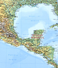 |
Location of the Yucatán Peninsula in relation to the rest of México and to portions of Central America, Cuba, and the United States.
Based on Hammond World Atlas (Hammond World Atlas Corp., 2000), p.196. |
|
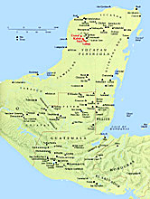 |
Major Maya sites and modern cities, showing rivers and terrain.
Based on Gene S. Stuart and George E. Stuart, Lost Kingdoms of the Maya (National Geographic Society, 1993), p.15. |
|
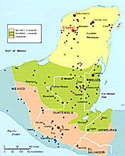 |
The 3 major Maya regions: Northern Lowlands, Southern Lowlands, and Highlands, with location of archaeological sites and modern national boundaries.
Based on Carolyn Hall and Héctor Pérez Brignoli, with John V. Cotten, Cartographer, Historical Atlas of Central America, (Norman: University of Oklahoma Press, 2003), p.59 |
|
 |
Northwest Yucatán Peninsula, showing modern cities and road, with Maya archaeological sites in red.
Based on Kevin Healey's Travel Map of México South East (Vancouver, B.C.: International Travel Maps, 1998). |
|
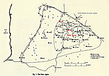 |
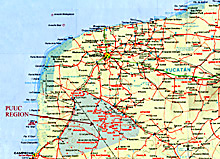
The Puuc Region, showing the density of Maya archaeological sites in the Puuc Region.
Based on George F. Andrews, Pyramids and Palaces, Vol. I, Architecture of the Puuc Region (Labyrinthos, 1995), fig.1. |
|
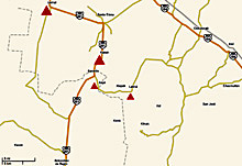 |
The central Puuc Region, showing locations of Uxmal, Kabah, Sayil, and Labná and current highways.
Based on Google Maps (http://maps.google.com/), "Yucatan Mexico", accessed March 2008. |
|
|
|
|
|
|